

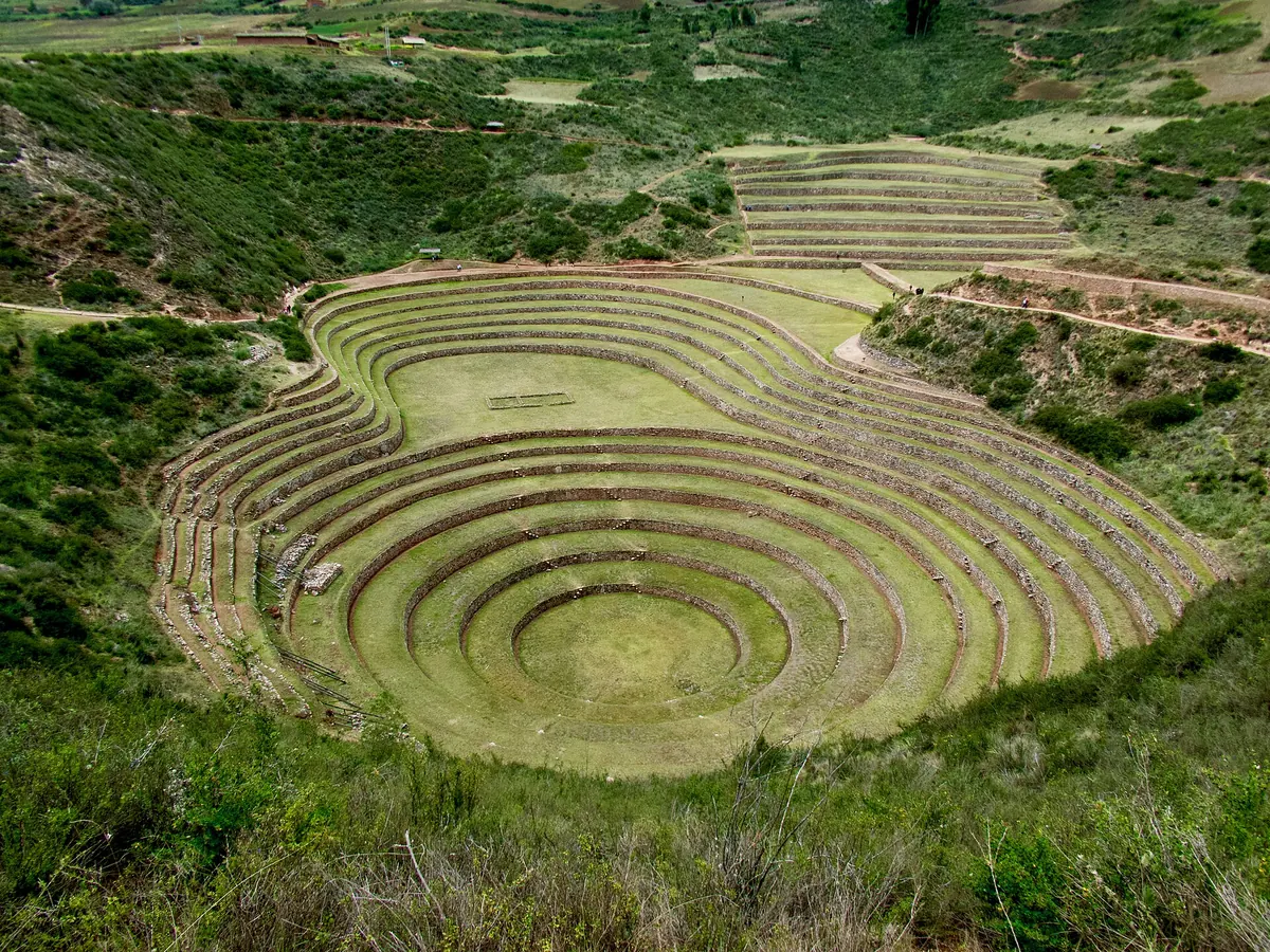
A mountain mosaic of farming environments
Elevation alone does not describe an Andean field. Slope aspect, water access, soil properties and local frost also matter. Valleys, hillsides and high plains provide different opportunities for crops and grazing. FAO describes Andean agricultural heritage as the combination of knowledge about these environments with the maintenance of diverse plants and animals. This was never one uniform system spread across the entire mountain range. It consisted of locally developed practices whose usefulness depended on the setting in which people applied them.
That diversity changes how a map of historical farming should be read. Nearby settlements could draw on different resources, making connections between them as important as the area of any individual field. Moving products between environmental zones could bring complementary supplies together. This should not be imagined as a set of perfectly regular belts where everybody grew the same crops. Evidence around Lake Acopia, for example, records cultivation alongside pastoralism and repeated changes in land use. A regional farming landscape was a changing arrangement of activities, rather than a fixed division of the mountains.13
A chronology that begins before the Inka Empire
Archaeological work around Huatta beside Lake Titicaca places raised-field cultivation within the first millennium BCE. This does not date every surviving field pattern to that period: individual areas were rebuilt, abandoned or brought back into use. A different sequence comes from the sediments of Lake Acopia in southern Peru. A study published in 2024 reconstructs a landscape containing crops and pastoral activity around 4,300 years ago. Its authors associate a later decline in erosion, around 2,300 years ago, with the development of agricultural terraces.
These are different forms of evidence operating at different scales. Lake sediments record changes in a surrounding catchment; they do not reveal the construction date of every retaining wall. At Acopia, later phases of agricultural expansion were compared with the Wari period and subsequent Inka expansion. The Inka state, which grew most dramatically in the fifteenth and early sixteenth centuries, therefore incorporated landscapes with substantial earlier histories. Assigning all terraces to that empire obscures the work of preceding communities and makes it harder to explain why neighbouring field systems followed different trajectories.237
Terraces: retaining soil and directing water
A terrace turns a sloping surface into land that is easier to cultivate, but its performance depends on more than the visible wall. The retaining structure supports a fill whose arrangement affects drainage. In examples from the Urubamba Valley presented by the Smithsonian, layers of stone, smaller material and soil form part of an engineered cross-section. Water must reach crops without accumulating uncontrollably behind the wall. The familiar staircase appearance therefore reveals only part of the structure. Looking at the surface alone can conceal the work required beneath it.
The Acopia research also places terracing within a whole catchment: altering land use on slopes can change the amount of eroded material reaching a lake. This does not prove that every terrace continuously prevented erosion. Maintenance, functioning drainage and the continuity of cultivation mattered. When interpreting an abandoned wall, its original design must be distinguished from subsequent repairs, slumps and vegetation growth. A surviving form may represent several episodes of work. The difference matters because an attractive photograph can suggest a single coherent design where archaeological evidence instead reveals a long sequence of adjustments.53
Titicaca raised fields: water, drainage and night-time cooling
Wet plains around Lake Titicaca required different responses from steep hillsides. Waru waru consist of raised cultivation ridges separated by depressions or canals. Raising the growing surface helped address excessive moisture around plant roots. Research on systems associated with Tiwanaku, dated in the relevant study to approximately 500–1100 CE, also examines heat exchange between moist soil, water and air. Although raised fields and terraces both reshape the ground, they are distinct technologies responding to different topographic and hydrological problems.
Ortloff and Kolata's 2023 modelling investigates how heat accumulated during the day could reduce cooling within raised beds overnight. Their calculations use specific climatic and water conditions from the southern shores of the lake. They do not demonstrate complete protection against every freezing event. Performance depends on field geometry, water levels and the properties of the underlying material. Experimental reconstruction can test these mechanisms, but a harvest from one reconstructed plot is not automatically the historical average for an entire region. A useful model clarifies what may have worked and why; it does not remove the need for local evidence.42
Crop diversity as agricultural knowledge
Potatoes, quinoa and maize were important components of Andean farming, but they were not interchangeable crops suited to identical conditions. Maintaining local varieties was also important within individual species. The International Potato Center describes Andean potatoes as a legacy of selection over generations, preserved on farms and exchanged between communities. Their diversity includes practical qualities and adaptation to local environments. A single crop name can therefore conceal a broad set of decisions about planting material, preferred uses and the places where particular varieties are maintained.
Combining crops with pastoralism gives a more useful picture of farming than treating a terrace bearing one crop as a self-contained production unit. An interpretive consequence is that food security should be considered across the available set of resources, rather than measured only by the largest harvest from one plot. This does not mean diversity eliminated crop failure. The Acopia environmental record contains changes in the intensity of farming, while modern efforts to conserve varieties around Cusco show that preserving this knowledge takes deliberate work and collaboration. Diversity is something communities maintain, rather than an automatic property of mountain landscapes.97310
After the harvest: chuño and qollqa storehouses
Agricultural production did not end with harvesting. Processing potatoes into the durable food known as chuño, together with the organisation of reserves, helped separate the time when food was produced from the time when it was consumed. The Smithsonian describes Inka qollqa, also written as colcas, as buildings used for food, clothing and other resources. Their siting and construction took advantage of ventilation. These structures bring preservation, storage conditions and the scheduling of supplies into the history of agriculture alongside fields and waterworks.
A storehouse is not, however, a straightforward measure of prosperity. Its capacity indicates a possible scale of storage, rather than providing a ready-made record of annual output or proving that everyone had equal access to reserves. Archaeological interpretation must establish what was kept there, when the building functioned and how it related to other infrastructure. Considering fields, storage points and routes together gives a better account of supply than treating each monument in isolation. Preservation was one part of a wider social arrangement, and the existence of that arrangement does not by itself reveal how its benefits and obligations were distributed.68
Labour, roads and the political scale of farming
The Qhapaq Ñan road system connected regions with very different environments. UNESCO emphasises that the Inka incorporated earlier routes while expanding communication, stopping places and storage infrastructure. Agricultural landscapes were consequently more than collections of isolated plots. Routes facilitated the movement of people and resources, while storehouses altered the organisation of supplies. This is an important setting for state expansion, although the presence of a road does not reveal by itself who used it most frequently or what obligations neighbouring communities faced.
Linking technology with political power requires care. An extensive field system need not have been created by one ruler, and a later administration could take over structures built earlier. Both the multiple phases at Acopia and raised fields that predate the Inka contradict a story centred on one moment of invention. Maintaining agricultural infrastructure involved repeated tasks: repairing damage, controlling water and preparing land for use. Historical analysis should therefore ask separate questions about initial construction, everyday operation and the ability to continue those activities after a change in political authority. A large investment could survive, change purpose or cease to function.8324
Researching and conserving a living agricultural landscape
Researchers combine excavation, dating, pollen and sediment analysis, and field experiments. These methods address different questions. Material inside a terrace fill may predate its latest rebuilding; reduced erosion in lake sediments requires an explanation; a thermal model describes a mechanism under stated conditions. The strongest interpretation emerges when independent evidence agrees. A reliable map should therefore distinguish a study location from the full distribution of a technology, just as a period of use should be distinguished from its first appearance. These distinctions make uncertainty informative rather than treating it as a gap to hide.
Present-day farms are not frozen replicas of the Inka Empire. Potato conservation projects around Cusco involve communities working with research institutions, exchanging planting material and returning varieties to cultivation. Continuity includes change. The historical value of terraces and waru waru lies in demonstrating different ways of managing demanding environments, rather than supplying a universal design for every modern farm. Assessing renewed use requires knowledge of local water, soils, labour and community needs. A structure may be technically promising while still requiring social arrangements that a reconstruction experiment alone cannot establish.3410
Questions and answers
Did the Inka invent Andean agricultural terraces?
No. Agricultural modification of slopes and plains has a much older and regionally varied history. The Inka expanded and incorporated earlier landscapes. Each field system needs to be dated using evidence from its own location.37
How do waru waru differ from hillside terraces?
Terraces provide cultivation surfaces on slopes. Waru waru are raised ridges separated by canals, found for example on the plains around Titicaca. Both manage relationships between soil and water, but they operate in different terrain.54
Did these systems completely remove the risk of frost?
No. Research identifies mechanisms that could reduce damage under particular conditions. Their effectiveness depended on water levels, field construction and weather. A local experimental result does not guarantee protection for every field or growing season.4
Sources
- FAO (n.d.). Andean Agriculture, Peru — Globally Important Agricultural Heritage Systems
- Clark L. Erickson (1988). Raised Field Agriculture in the Lake Titicaca Basin: Putting Ancient Agriculture Back to Work
- Courtney R. Shadik et al. (2024). The Evolution of Agrarian Landscapes in the Tropical Andes CC BY 4.0
- Charles R. Ortloff and Alan L. Kolata (2023). Fluid and Thermal Analysis of Pre-Columbian Tiwanaku (500–1100 CE) Raised-Field Agricultural Systems of Bolivia CC BY 4.0
- Smithsonian National Museum of the American Indian (n.d.). The Inka Empire — Explore Water Management
- Smithsonian National Museum of the American Indian (n.d.). The Inka Empire — Preservation and Storage
- Smithsonian National Museum of the American Indian (n.d.). The Inka Empire: What Innovations Can Provide Food and Water for Millions?
- UNESCO World Heritage Centre (n.d.). Qhapaq Ñan, Andean Road System
- International Potato Center (n.d.). Native Potato Varieties
- FAO, International Treaty on Plant Genetic Resources for Food and Agriculture (n.d.). Conservation and Sustainable Use of Native Potato Diversity in the ‘Potato Park’; Cusco, Peru
Approximate dates (c.) describe the nature of the evidence: archaeology dates settlements, layers and remains, not single moments of invention.