

Place and time: one basin, several histories
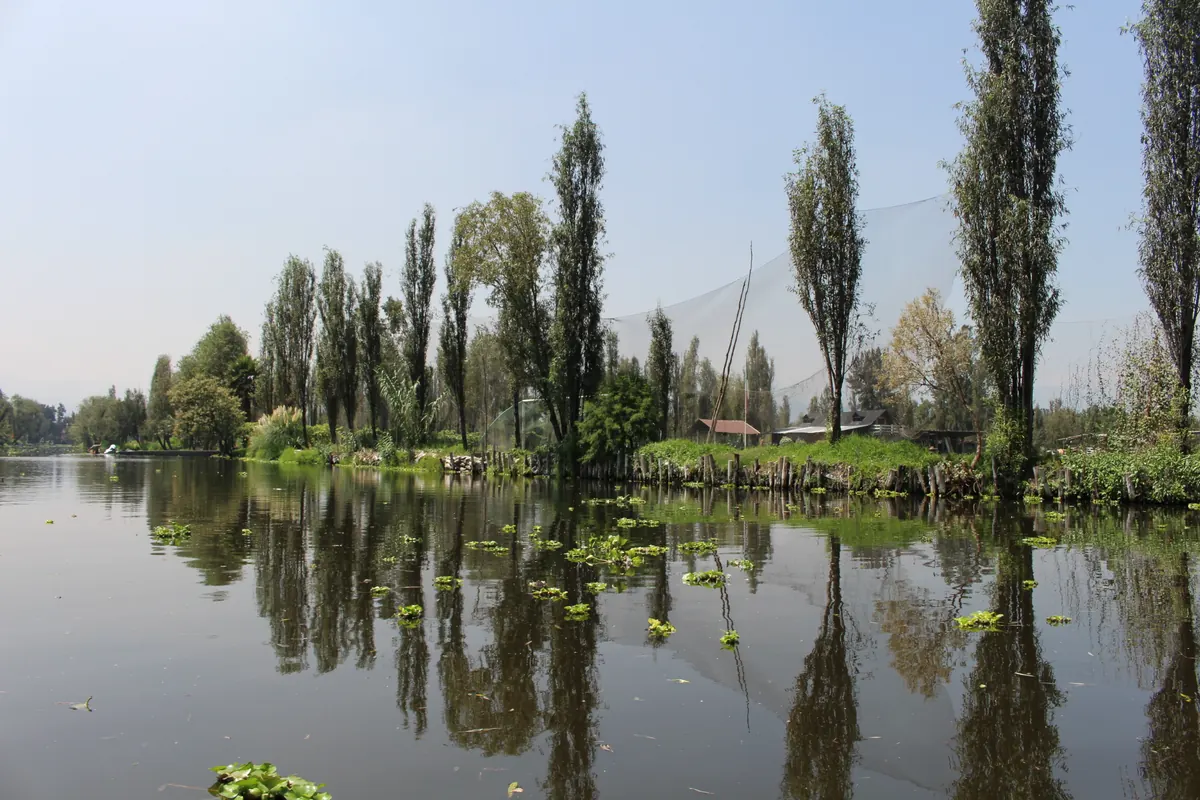
Xochimilco now lies in southern Mexico City and preserves part of what was once a much larger lake landscape. Chinampas also existed elsewhere in the basin. A 2024 account from Mexico's National Institute of Anthropology and History identifies the earliest examples located so far with the Early Postclassic period, approximately 900–1200 CE, including remains at Xaltocan. This dates recognised evidence. It should not be read as an exact moment of invention or as proof that all fields originated at the same time.
Distinguishing Xaltocan from Xochimilco is essential. The former belonged to the northern basin, while the latter represents its southern wetlands. Lake extent, water conditions and political developments varied between places. The later power of the Mexica should therefore not obscure earlier initiatives by other communities. A historical map needs several locations, and a timeline must allow for overlapping phases of use, enlargement and abandonment. Treating every surviving field as a product of the same empire replaces a complex regional history with a misleadingly simple origin story.139
Building a chinampa: a field rather than a raft
A chinampa was an artificially formed plot anchored to its setting, rather than a boat or a garden freely floating on water. Teresa Rojas Rabiela describes several ways of building agricultural ground from local vegetation, earth and mud. Material was accumulated in shallow or marshy places until a cultivation surface was established. Construction methods were not identical everywhere, and plot dimensions changed over time. A modern photograph should consequently not be treated as the standard plan for all historical chinampas, regardless of date or location.
Ahuejotes, native willows planted around field margins, are important features of Xochimilco's landscape. Arroyo-Lambaer and colleagues describe their contribution to retaining soil and sheltering plots. A field boundary consequently joins earth, vegetation and water. This leads to an important interpretation: a chinampa cannot be understood as a mound alone. Its operation depends on neighbouring canals, roots and repeated labour. Filling a canal may enlarge an individual plot while changing the connections that allow the wider system to function. The cultivated surface and the spaces around it form a single working arrangement.210
Canals: water supply, drainage and movement
Canals performed several functions at once. They separated cultivation surfaces, enabled access by boat and formed part of local water circulation. Moisture could also reach soils through capillary movement, making the relationship between field height and water level important for growing conditions. FAO presents chinampa agriculture as a combination of plots, canals, trees and varied cultivation practices. Considering those elements together explains why simply placing a ditch beside a raised bed does not recreate the complete system developed in the Basin of Mexico.
Water also imposes limits. Research on present-day Xochimilco describes problems involving both its quality and its quantity, including pressures associated with urbanisation and changes to canal replenishment. A successful historical technique is not automatically resistant to every pollutant or alteration in lake level. The interpretive consequence is that a plot needs to be assessed together with the surrounding network. A field may appear intact even when its hydrological conditions have changed substantially. Preserving its outline is therefore different from preserving the relationships that make it usable for agriculture.610
Seedlings, soil and the rhythm of field work
One characteristic practice involves chapines: small blocks of moist material used to raise seedlings. A contemporary account from Mexico's agriculture ministry describes using mud to prepare a seedbed and dividing its surface into small units. Plants can begin growing there before being moved to their final position. This separates early growth from occupation of the main cultivated area. It is an example of technical knowledge carried through a sequence of practical actions, rather than a property of the landscape that operates without continuing attention.
Intensive cultivation nevertheless depended on combined practices and the organisation of labour, rather than on one exceptional soil ingredient. Raising seedlings, tending plants, maintaining margins and moving material all take time. The possibility of successive sowings depends on the crop, water conditions and available workers. Modern documentation helps explain how a technique functions, but it does not justify transferring every detail unchanged into the ninth, fourteenth or sixteenth century. Evidence from a living farm and evidence from an archaeological deposit answer different questions; both become more useful when that distinction is made explicit.7610
Food production and the supply of urban centres
Chinampas increased opportunities for production in a heavily used basin, while water routes helped connect fields with consumers. This does not mean that each city depended exclusively on its nearest plots. UNAM's material on the Mexica economy describes a wider supply system, including products arriving from beyond the immediate urban surroundings. Agricultural history therefore needs to consider both work within fields and connections between producers, exchange and political institutions. High productivity is relevant, but by itself it does not explain an entire city's food economy.
Morehart's 2016 analysis reconstructs the possibility of a caloric surplus from the Xaltocan system. This is an estimate of productive potential assembled from several kinds of evidence, rather than a surviving register of actual harvests in every season. The outcome depends on assumptions about area, yields, population and labour requirements. Numbers in popular accounts should therefore be presented with their underlying assumptions. Comparing alternative scenarios can be informative, while a single impressive figure without context conceals uncertainty. Potential output, harvested output and food ultimately available to households are related quantities, not interchangeable ones.84
Xaltocan: political disruption without the disappearance of a technology
Morehart and Frederick combine landscape investigation, excavation and radiocarbon dating. Their results indicate that the extensive raised fields around Xaltocan were abandoned following its conquest by neighbouring powers in the fourteenth century. This challenges any account in which all chinampa systems expanded continuously until the Spanish arrival. A technique could remain useful while a particular network ceased to operate because its social setting changed. The end of one local field system does not supply a date for the disappearance of chinampa agriculture across the basin.
Comparing this case with the later persistence of cultivation in southern areas separates three questions: whether people knew the technique, whether infrastructure was maintained and who controlled land. None follows automatically from the others. Present-day studies likewise identify farming identity, social relationships, income and water problems as factors in household decisions. That does not establish identical motivations in medieval Xaltocan. It offers a methodological reminder that farmers operate within social relationships. Describing soil and potential harvests alone cannot fully explain a decision to keep cultivating a plot, change its use or leave it.31210
What aerial images, excavations and dates can reveal
Old fields can be difficult to recognise from ground level, especially after drainage or changes to surrounding land. Morehart's 2012 study used historical aerial photographs, satellite imagery and geographic information systems to investigate patterns in the northern basin. Comparing images from different periods can help distinguish traces of earlier land organisation from later development. A map of visible lines is nevertheless a starting point. Field evidence is needed to investigate what those features were and when they were used; not every repeated pattern has the same origin.
Excavation and dated samples permit more specific questions about cultivation or the filling of a canal. The age of one material should not be equated automatically with the age of an entire network. Similarly, estimating past harvests requires a model with explicit assumptions. A professional account should identify whether a statement comes from observing a structure, a laboratory measurement, a historical document or a calculation. These distinctions help readers understand why some dates are expressed as ranges and why interpretations can change with further research. Uncertainty is part of reconstructing an inhabited landscape, rather than evidence that no useful history can be written.534
Xochimilco: heritage that still produces food
Xochimilco forms part of the UNESCO inscription covering Mexico City's historic centre and the canal landscape. Heritage recognition alone does not resolve farmers' difficulties. Arroyo-Lambaer and colleagues' 2022 study emphasises water and soil quality, costs and access to markets. It also considers limitations of environmental certification: adding a label does not remove problems that producers already face. Maintaining an agricultural landscape therefore involves the work and livelihoods of the people who sustain it, as well as conserving the features visible to visitors.
The chinampa-refugio model described by UNAM illustrates links between cultivation and ecological restoration. It involves collaboration with producers and improvements to side canals, including measures intended to restrict non-native fish from refuges for local species. This is a contemporary intervention, rather than proof that an ancient system has remained unchanged. Chinampa history is valuable precisely because it reveals continuing adjustments between land, water and the city. Protecting views without functioning farms and canals would retain only part of that heritage. Its future depends on the relationships that keep cultivation possible, not simply on preserving the appearance of old plots.91011
Questions and answers
Do chinampas actually float?
Cultivated chinampas are fixed raised fields connected to the underlying landscape. The expression ‘floating gardens’ does not literally describe their construction. They should not be confused with the tourist boats travelling through Xochimilco's canals.2
Sources
- Instituto Nacional de Antropología e Historia (2024). El sistema chinampero de la Cuenca de México, en la nueva edición de Arqueología Mexicana
- María Teresa Rojas Rabiela (1993). Las chinampas de México: métodos constructivos
- Christopher T. Morehart and Charles Frederick (2014). The chronology and collapse of pre-Aztec raised field (chinampa) agriculture in the northern Basin of Mexico
- Christopher T. Morehart (2016). Chinampa Agriculture, Surplus Production, and Political Change at Xaltocan, Mexico
- Christopher T. Morehart (2012). Mapping ancient chinampa landscapes in the Basin of Mexico: a remote sensing and GIS approach
- FAO (n.d.). Chinampas Agricultural System in Mexico City — Globally Important Agricultural Heritage Systems
- Secretaría de Agricultura y Desarrollo Rural, México (2022). El chapín, técnica de siembra ancestral
- Universidad Nacional Autónoma de México, Portal Académico CCH (n.d.). Economía — Cultura mexica
- UNESCO World Heritage Centre (n.d.). Historic Centre of Mexico City and Xochimilco
- Denise Arroyo-Lambaer et al. (2022). Identifying Urban Agriculture Needs and Challenges for the Implementation of Green Labeling in Xochimilco, Mexico CC BY
- Universidad Nacional Autónoma de México, Dirección General de Comunicación Social (2025). ¡Súmate al rescate de ajolotes y de Xochimilco!
- Patricia Pérez-Belmont, Amy M. Lerner, Marisa Mazari-Hiriart and Elsa Valiente (2021). The survival of agriculture on the edge: Perceptions of push and pull factors for the persistence of the ancient chinampas of Xochimilco, Mexico City
Approximate dates (c.) describe the nature of the evidence: archaeology dates settlements, layers and remains, not single moments of invention.