

Key dates
- Late ninth centuryThe Indratataka is constructed during Hariharalaya’s development.5
- Around the ninth–tenth-century transitionThe East Baray accompanies the royal centre’s northwestward shift.5
- First half of the eleventh centuryThe West Baray is constructed; its precise building date remains uncertain.12
- Late twelfth–early thirteenth centuriesThe Jayatataka is incorporated into Angkor’s established infrastructure.15
- Fourteenth–early fifteenth centuriesRegional evidence indicates prolonged droughts interspersed with intense monsoons.14
- Late fourteenth–early fifteenth centuriesDates indicate renewed use of some occupation mounds at Angkor Wat.17
A city among fields: Angkor’s agricultural geography
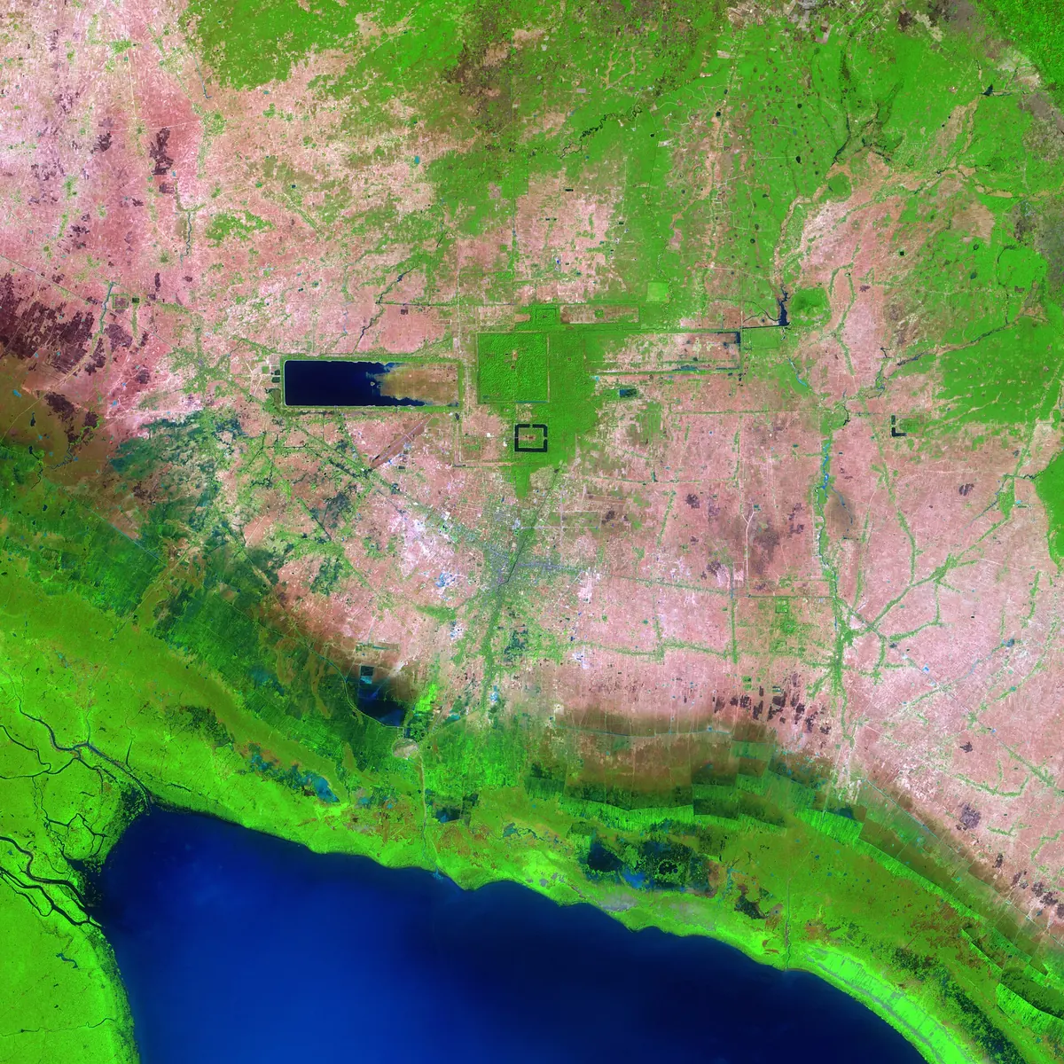
Angkor developed across the plain between the Kulen hills and Tonle Sap Lake. Seasonal abundance did not ensure water was equally accessible throughout the year. Houses, roads, cultivated land and religious sites formed a dispersed settlement landscape. A map published in 2007 covered almost 3,000 square kilometres of the study region and identified a water management network extending over more than 1,000 square kilometres. The research area must not be confused with uniformly built urban land or the boundaries of the archaeological park. Those measurements describe different things.
A demographic model published in 2021 estimated approximately 700,000–900,000 inhabitants in Greater Angkor at its thirteenth-century peak. This is a reconstructed range based on settlement evidence and household assumptions, not a medieval census. It nevertheless conveys the scale of everyday provisioning. Water served residents, agriculture and institutions whose personnel needed food. Stone monuments survive most visibly, but their operation depended on less conspicuous productive spaces and settlements. Understanding Angkor therefore requires moving between monumental architecture and the households that sustained it.241
Baray reservoirs and successive generations of construction
Large reservoirs known as baray were built during successive phases of capital development. The Indratataka is associated with Hariharalaya and Indravarman I in the late ninth century. Under Yasovarman I, as the centre shifted northwest, the East Baray was constructed. The West Baray dates to the first half of the eleventh century; the Jayatataka belongs to Jayavarman VII's building programme around the late twelfth and early thirteenth centuries. These works represent generations of spatial change, not the execution of one original master plan.
The West Baray measures approximately eight kilometres by two. Its scale draws attention to stored water, but its connections and position relative to cultivated land mattered equally. Earthen embankments used material excavated along their inside edges. Construction transformed an existing landscape and had to interact with older settlement and circulation patterns. Later projects also reorganized an increasingly interconnected network, in which a new element could alter the operation of previous structures. Reservoir history consequently involves the changing relationships between installations as much as the dimensions of any individual basin.512156
Storing, distributing and draining water
Research on channels, inlets, outlets and spillways challenged the claim that Angkor's reservoirs were exclusively symbolic bodies of water lacking practical connections. It does not establish the opposite simplification that every baray always served irrigation alone. The network intercepted water, moderated its movement, retained some and directed surplus towards the lake. Supplementing shortages and managing excessive flows were both important. Economic and ritual purposes could coexist within the same landscape, while an installation's function could change as neighbouring works were rebuilt.
Embankments influenced water movement but could also provide raised routes across seasonally wet ground. Diversions reshaped catchment boundaries and transmitted the effects of construction beyond the immediate work site. Earlier debates about the “hydraulic city” were constrained by incomplete maps that emphasized famous reservoirs over their surroundings. Interpreting the whole system requires connecting major structures to ponds, smaller channels and topography. Reservoir capacity by itself cannot explain when water was available, where it could travel or which households could benefit from it.67132
Rice, gardens and households within temple landscapes
Rice was fundamental, but archaeobotanical work at Angkor Wat and Ta Prohm reveals a broader repertoire of plants. Identified remains include mung beans, long pepper and cotton alongside rice. The evidence connects food, household gardens, craft activities and temple practices. A plant could contribute to a meal, an offering or another part of the household economy rather than serving one exclusive purpose. Temple enclosures also contained ordinary people's living spaces. Their histories cannot therefore be reconstructed solely as ceremonial areas reserved for kings and elites.
Airborne laser scanning revealed subtle variations in ground elevation beneath vegetation: occupation mounds, ponds, routes and spatial divisions. Houses made from organic materials disappeared, while traces of their surroundings survived. These settlements connect monumental architecture with the daily work of the people who supported it. Agricultural space was intertwined with other urban activities. A large estimated population does not, however, prove that every field received reservoir irrigation or that the whole region consistently harvested rice the same number of times each year. Such claims require separate agricultural evidence.834
Temples, landholding and the allocation of labour
Water was a social resource as well as an environmental one. State infrastructure coexisted with local communities centred on temples, small reservoirs and households. Spatial analysis identifies connections between these communities and larger works, followed over time by increasing importance for substantial units controlled by elites and the state. Angkor cannot be explained through a simple choice between autonomous villages and one authority directing every field. Relationships between levels of management changed as settlement grew and control over resources became more concentrated.
Inscriptions list land, personnel and rice allocations supporting religious foundations. Provisioning in kind connected offerings to deities with the maintenance of people working in temples. These records expose hierarchy and dependency, including workers described as enslaved or bound to a foundation, although they do not preserve complete household accounts. Research on land transactions also identifies a weakening of some middle-ranking officials and transfers towards higher elites. The history of canals thus includes rights over land, obligations to institutions and unequal access to the benefits of production.91011
Maintenance and the environmental archive in sediment
The system depended on repeated intervention after construction. Strong flows could erode channels, while slower water encouraged sediment deposition. Diverting a river changed the material arriving farther downstream. Hydrologist Matti Kummu showed how artificial modifications to catchments and channel gradients generated problems of erosion and sedimentation. Infrastructure was an operating arrangement within a changing environment: improvements in one location could increase maintenance demands elsewhere. The landscape was not a machine that continued indefinitely without adjustment once its principal components had been built.
A sediment core from the West Baray preserves approximately a millennium of change. Research published in 2012 found substantial mineral inputs through the thirteenth century, followed by reduced accumulation. The authors related this to water management, catchment land use and climate. Sediment is neither a population count nor a maintenance diary, but records consequences of interacting processes. By the seventeenth century the reservoir again displayed characteristics of a lake environment, complicating accounts of permanent destruction.71213
Drought, intense monsoons and infrastructural vulnerability
Tree rings in southern Vietnam revealed prolonged weakening of the monsoon during the fourteenth century and another drought in the early fifteenth. Dry intervals were interspersed with exceptionally wet years. Agriculture and hydraulic works faced inadequate supply followed by damage from excessive flows. This regional evidence must be assessed alongside Angkor’s archaeology. It does not measure rainfall over every field or explain political decisions independently, but identifies changing stresses on an evolving society.
A network model published in 2018 demonstrated how local flow changes could generate cascading damage across connected channels. In the simulation, vulnerability rose with flood magnitude relative to ordinary flows. This tests a mechanism; it does not reconstruct one precisely dated, documented disaster. The result nevertheless explains an important infrastructure problem: connections that help distribute resources can also transmit failures. Resilience depends on network structure, external conditions and people's capacity to repair or reorganize the installations on which their fields and settlements rely.1415
Angkor’s transformation beyond a single collapse date
The year 1431, often associated with Angkor's capture by Ayutthayan forces, did not mark a simultaneous end to every settlement and field. Sediment from the Angkor Thom moat indicates declining land-use intensity in the central zone from the early fourteenth century. Indicators of burning, vegetation disturbance and erosion diminished. Researchers connect this evidence with a longer relocation of power, neighbouring states' ambitions and opportunities associated with maritime trade. Changes could unfold at different rates across the region rather than following one citywide timetable.
Excavations at Angkor Wat reveal another sequence. After earlier occupation and a gap in the dating evidence, some mounds were used again from the late fourteenth or early fifteenth century into the seventeenth or eighteenth. The temple was never wholly abandoned. Infrastructure damage, court relocation, changes in cultivation and continuing religious practices consequently need distinct explanations. Angkor's heritage is a landscape repeatedly transformed by people over many centuries. Its protection concerns relationships between monuments, water and inhabited surroundings, as well as the impressive stone buildings that remain visible today.16171
Questions and answers
Were all baray reservoirs used exclusively for irrigation?
No. Interpretations include water storage, distribution and drainage alongside ritual functions. Individual installations could change purpose over time.6
Sources
- UNESCO World Heritage Centre (n.d.). Angkor — description and Outstanding Universal Value
- Damian Evans et al. (2007). A comprehensive archaeological map of the world’s largest preindustrial settlement complex at Angkor, Cambodia
- Damian H. Evans et al. (2013). Uncovering archaeological landscapes at Angkor using lidar
- Sarah Klassen et al. (2021). Diachronic modeling of the population within the medieval Greater Angkor Region settlement complex
- Alison K. Carter et al. (2021). The evolution of agro-urbanism: A case study from Angkor, Cambodia
- Roland Fletcher et al. (2008). The water management network of Angkor, Cambodia
- Matti Kummu (2009). Water management in Angkor: Human impacts on hydrology and sediment transportation — abstract in FAO AGRIS
- Cristina Cobo Castillo et al. (2020). The Khmer did not live by rice alone: Archaeobotanical investigations at Angkor Wat and Ta Prohm
- Sarah Klassen and Damian Evans (2020). Top-down and bottom-up water management: A diachronic model of changing water management strategies at Angkor, Cambodia
- Terry Lustig and Eileen Lustig (2015). Following the Non-Money Trail: Reconciling Some Angkorian Temple Accounts
- Eileen Lustig and Terry Lustig (2019). Losing ground: Decline of Angkor’s middle-level officials — abstract
- Mary Beth Day et al. (2012). Paleoenvironmental history of the West Baray, Angkor (Cambodia)
- Dan Penny et al. (2005). Hydrological History of the West Baray, Angkor, revealed through Palynological Analysis of Sediments from the West Mebon
- Brendan M. Buckley et al. (2010). Climate as a contributing factor in the demise of Angkor, Cambodia
- Dan Penny et al. (2018). The demise of Angkor: Systemic vulnerability of urban infrastructure to climatic variations
- Dan Penny, Tegan Hall, Damian Evans and Martin Polkinghorne (2019). Geoarchaeological evidence from Angkor, Cambodia, reveals a gradual decline rather than a catastrophic 15th-century collapse
- Alison K. Carter et al. (2019). Temple occupation and the tempo of collapse at Angkor Wat, Cambodia — abstract in UCL Discovery
Approximate dates (c.) describe the nature of the evidence: archaeology dates settlements, layers and remains, not single moments of invention.