

Key dates
A lake within a low-lying landscape
Beemster belongs to the Dutch droogmakerijen, areas created by draining lakes. That distinction matters: not every polder originated by enclosing a piece of open sea. In North Holland, earlier flood defences coexisted with extensive inland waters. This project transformed a particular lake into agricultural land, and its surrounding dyke retained a relationship with the former shoreline. Its history should therefore begin with the actual water body, rather than a generic image of land conquered from the ocean.
The new land was intended to produce income and food, while controlling the lake would reduce danger to surrounding areas. The venture belonged to the expansion of towns, commerce and land markets in the seventeenth-century Netherlands. This was not a landscape created solely through individual households gradually extending their fields. Shared infrastructure and spatial divisions were planned first, establishing conditions on which later farming depended. Beemster demonstrates how the foundations of agriculture could be constructed at the scale of an entire landscape.198
A concession, investment and the setback of 1610
In May 1607 wealthy Amsterdam merchants and senior officials obtained permission to drain the lake. Work on the enclosing dyke, ring canal and pumping equipment began the following year. Progress was not an uninterrupted success: a storm in January 1610 caused renewed flooding, and much of the work had to be repeated. Further funds were secured, allowing the project to be completed in 1612. The outcome depended on the ability to recover from a major setback as well as on the original design.
For investors, drainage converted capital into land whose value would arise from future use. For those carrying out the scheme, it involved earthworks, material supplies, surveying and operating equipment. Technical risk was also financial risk: damaged defences could undermine the value of work already completed. The flood of 1610 helps explain why the history of a polder cannot be reduced to an idea or one invention. It required an organisation capable of surviving expensive delay and committing resources before ordinary agricultural returns became available.248
How drainage worked: dykes, ditches and lifting water
The dyke separated the polder’s interior from outside water, but it did not remove rainfall or seepage. Water from the parcels had to reach ditches and larger collecting channels. Where the receiving water stood above the area being drained, gravity alone could not provide an outlet: the water had to be lifted. Windmills driving water-moving equipment supplied the necessary energy. Larger differences in level could be addressed through successive stages that transferred water to higher parts of the system.
A conceptual diagram should therefore distinguish low farmland, internal channels, lifting equipment and the ring canal connected to the wider water network. The dyke acts as a barrier, while pumping enables controlled movement across the difference in levels. Drawing an unrestricted downhill flow from the polder floor directly into the sea would be misleading. This representation explains the principle without pretending to reconstruct every historical installation, its capacity or its precise elevation. The functioning unit was a connected water system, not a collection of independent machines.549
Geometry as a practical way to organise land
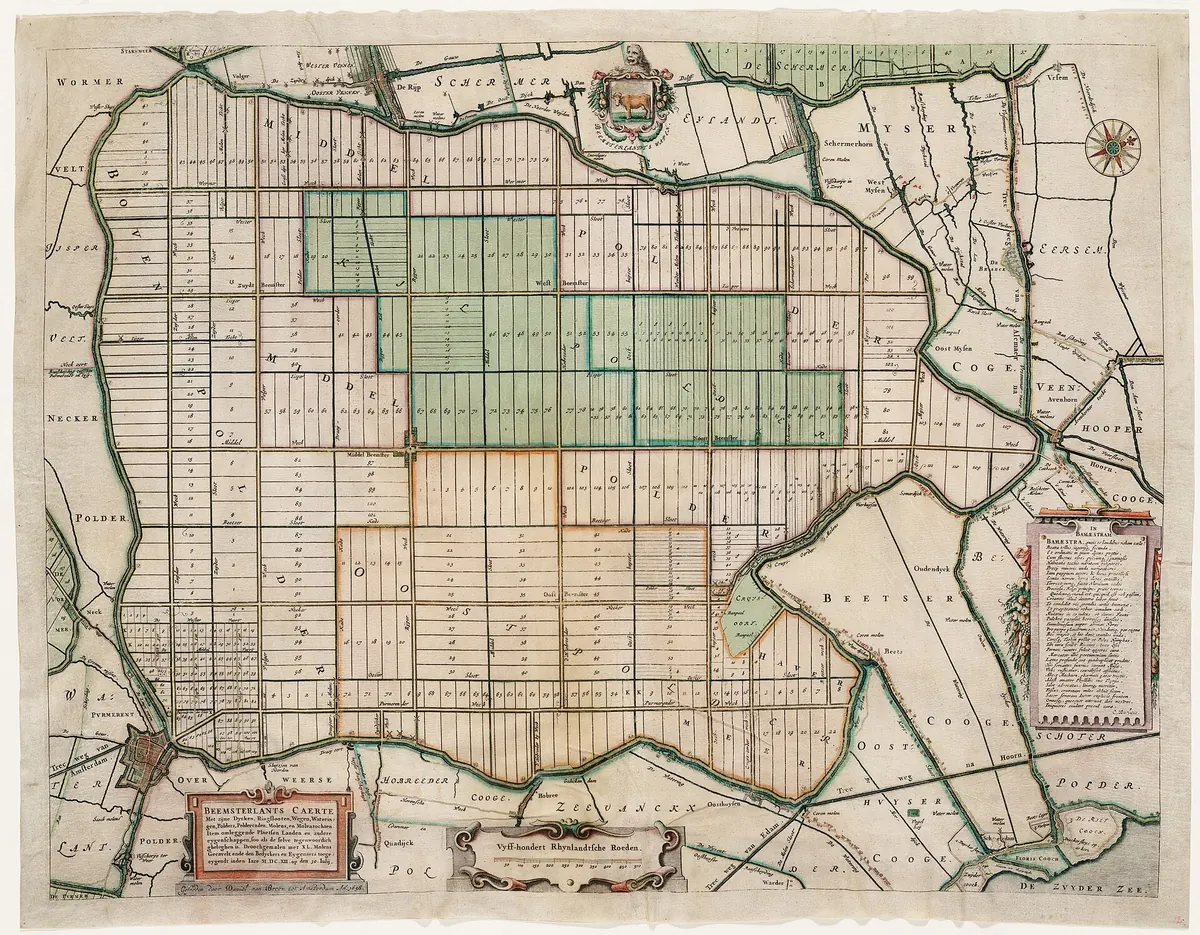
Beemster’s design linked roads, waterways and parcels in a regular grid. Larger squares contained smaller units and elongated plots. The arrangement helped define boundaries, access and drainage while expressing ideals of order associated with classical antiquity and the Renaissance. Geometry was not a decoration added after construction. It was a way to organise land that had yet to be occupied and cultivated, connecting a visual plan to the infrastructure of future farming.
Regularity nevertheless had to accommodate the actual site. The outer boundary followed the lake, requiring designers to reconcile a clear pattern with an irregular shoreline. Road intersections, proposed settlements and the relationship between buildings and plots also mattered. For historians, a map reveals both a spatial programme and a structure of future economic relationships. A road provided access to a farm, a ditch served its drainage, and a boundary identified the portion of land assigned for use. Reading these elements together is more informative than treating the grid simply as an attractive pattern.172
Surveying and the labour of many people
Jan Adriaenszoon Leeghwater is among the best-known individuals associated with the undertaking. Records discussed by the regional water authority identify his role in supervising mill construction. This does not mean that he personally designed and built the entire polder. Surveyors, builders, mill operators, earthworkers and administrators were required. Measurements preceded the allocation of land, and operating the equipment involved continuing work under changing wind conditions.
It is easy to remember an engineer’s name while overlooking people who dug channels or maintained an embankment. Yet the project’s economic significance depended on combining specialised tasks. A correctly surveyed plot was of little use without drainage, and an effective mill could not protect land without a channel and dyke. This division of labour distinguishes a major water project from an improvement on a single farm. An account of Beemster should therefore explain the organisation of collective effort, as well as the biography of a prominent participant. Expertise mattered through the arrangements that allowed people to apply it together.649
From a drained lake bed to farms and pasture
Removing the lake did not instantly create a complete agricultural settlement. Parcels had to be allocated and made accessible, buildings constructed and production established. Owners leased land to farmers, so the provision of investment and the daily work of cultivation did not necessarily belong to the same people. Local history records the initial importance of arable crops and a subsequent emphasis on livestock, dairying and cheese-making. Changing land use demonstrates that a spatial plan did not permanently determine every aspect of the economy.
Farmers had to consider more than a parcel’s area. Soil condition, access to water, the transport of products and operating costs all mattered. Channels did not express an ambition to remove every drop of moisture. The purpose was to maintain conditions appropriate to the land’s use. Polder history therefore concerns both the enlargement of the agricultural land resource and the adjustment of activities to its characteristics. The new landscape required knowledge accumulated through successive working seasons, rather than only the plan prepared before drainage. Building a farm economy remained a distinct task after the hydraulic works.359
A farming landscape connected to urban capital
Beemster combined agricultural production with country residences for wealthy urban inhabitants. A farm could stand alongside a garden or rooms reserved for an owner’s summer visits. Characteristic stolp farmhouses, with compact forms and high roofs, fitted the geometric arrangement of the landscape. They were not all built in one year or used in an identical way. The built environment continued to develop after the main drainage works were complete.
This combination is a reminder that agricultural history includes relationships between town and countryside. The city supplied investment and demand; the polder offered land, produce and space for leisure. An owner’s return and a tenant’s working conditions were nevertheless different questions. Evaluating the undertaking requires distinguishing hydraulic effectiveness, investment profitability and residents’ everyday lives. An elegant plan did not remove differences in wealth among the people who used it. The same landscape could be a source of rent, a place of work and a setting for seasonal retreat, depending on whose experience is being examined.1239
1612 marked the start of a continuing obligation
Energy sources and drainage installations changed over time. Pumping stations eventually replaced windmills, but agriculture’s dependence on a functioning water system remained. A polder is not land drained once and then left without attention. Channels need maintenance, dykes require inspection, and water management needs coordination across parcel boundaries. Shared infrastructure creates continuing obligations that do not end when land is assigned to investors. Ownership and operation remain connected through the physical conditions of the landscape.
World Heritage inscription in 1999 drew attention to the entire composition of fields, roads, water and buildings, and to their relationships. It does not imply that every element has survived unchanged since 1612. Conserving such a place concerns a working agricultural landscape, rather than a frozen stage set. Beemster shows that acquiring land and maintaining it are parts of the same history. The success of drainage must also be assessed through the ability of later generations to farm a space dependent on collective water management. Its longevity rests on adaptation as well as the survival of the original design.1795
Questions and answers
Was Beemster reclaimed directly from the sea?
Lake Beemster was drained. It is an example of a droogmakerij, a polder created from a lake. Dutch polders have different origins and were not all formed by enclosing open sea.19
Sources
- UNESCO World Heritage Centre (n.d.). Droogmakerij de Beemster (Beemster Polder) UNESCO description: CC BY-SA IGO 3.0
- Hoogheemraadschap Hollands Noorderkwartier (n.d.). The Beemster
- Gemeente Purmerend (n.d.). Geschiedenis van de Beemsterpolder
- ICOMOS (1999). Beemster Polder (The Netherlands), No. 899: advisory body evaluation
- Hoogheemraadschap Hollands Noorderkwartier (n.d.). Living safely below sea level: sufficient fresh water and water-level management
- Hoogheemraadschap Hollands Noorderkwartier (n.d.). De Beemster: Leeghwater and the construction of the mills
- Stichting Werelderfgoed Nederland (n.d.). Droogmakerij de Beemster
- Bezoekerscentrum Beemster / VISIT Beemster (n.d.). Welkom in de Werelderfgoedzaal
- Steffen Nijhuis (2019). The Noordoostpolder: A Landscape Planning Perspective on the Preservation and Development of Twentieth-Century Polder Landscapes in the Netherlands CC BY-NC-ND 4.0; cited for comparative context
Approximate dates (c.) describe the nature of the evidence: archaeology dates settlements, layers and remains, not single moments of invention.